Weet u zeker dat u deze actie wilt uitvoeren?
Diesel
€ 1,69
GTL Fuel & HVO100
€ 1,99
-
- Filters
- Bilgepompen
-
Anodes
- Fixing Bolts
- Anode For Airconditioning
- Areator Anode
- Brush Replacement
- Saildrive Anodes
- Screw Kit
- Zinc Spray
- Earthing Plate
- Shaft Grounding
- Bowthrust Anodes
- Engine Anodes Kits
- Trim Tab Anodes
- Divers Anodes
- Boiler Anodes
- Water Pumps Anodes
- Inboard Engine Pencils
- Engine Anodes
- Long Bar Anodes
- Suspended Anodes
- Disc Anodes No Holes
- Rod Anodes
- Shaft Anodes Collar Type
- Shaft Anodes HD Steel Insert
- Shaft Anodes Egg Type
- Propellor Anodes
- Weld On Anodes Alu Strip
- Weld On Anodes Ingot Type
- Weld On Anodes
- Crab Trap Anodes
- Bolt On Anodes
- Aluminiumanodes
- Magnesiumanodes
- Zinkanodes
- Pvc & Rubber
- Slangen & Fitwerk
- Ankeren
- Verwarming
- Brandstof
-
Motor & Manoeuvreersystemen
- Ventilatie
- Hydraulische Besturing
- Helmstokbesturing
- Stuursystemen
- Outboard & Toebehoren
- Uitlaatsystemen
- Schroeven & Assen
- Schroeven Vetus
- Motoronderhoud
- Afstandbediening
- Geluidsisolatie
- Elektrische Aandrijving
- Motoren
- Motoronderdelen
- Motormanagement
- Boegschroeven
- Boegschroeftoebehoren
- Motoronderdelen Per Motor
- Stroom Motor & Techniek
- Outlet
-
Winkelmand
Je winkelwagen is leeg.
Imray
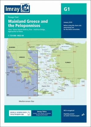
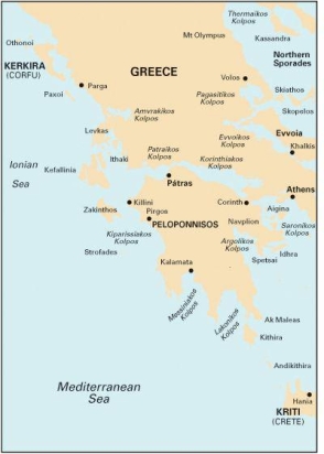
G1 Mainland Greece and the Peloponnisos
€ 35,50
Dit bestellen wij voor u bij onze leverancier
- Binnen 1-3 werkdagen in huis
- Wereldwijde verzending
- Veilig betalen met iDeal, Bancontact of Bankoverschrijving
Productomschrijving
G1 Mainland Greece and the Peloponnisos
Passage Chart
De G zeekaarten van Imray zijn overzichtskaarten en detailkaarten van Griekenland, Turkije en Kreta:
Op de cover / afbeedling van de betreffende kaart vindt u de editiedatum.
Plans included:
Vórion Stenón Kérkiras (1:70 000)
Ríon - Andírrion Bridge (1:30 000)
Approaches to Pátras (1:15 000)
On this 2017 edition the latest firing practice areas are included. The chart has been re-schemed. The plan of Órmos Falírou has been removed and plans of Vórion Stenón Kérkiras, Ríon - Andírrion Bridge and Approaches to Pátras are included. The chart specification has been improved to show coloured light flashes. There has been general updating throughout.
Deze waterkaarten zijn gevouwen tot A4 formaat en de totale afmeting is 787x1118mm.
Tot er een nieuwe editie wordt uitgegeven kunt u hier correcties downloaden.
Specificaties
| Artikelnummer | VROL16G1 |
| Model | 16G1 |
Wilt u advies of heeft u een vraag?
We doen ons best u zo snel mogelijk te antwoorden. Weet u al een artikelnummer of heeft u een foto? We zijn voor spoedvragen ook bereikbaar op ons WhatsAppBusiness account. Whatsapp ons!


